

The Price of Acceptability for New Transmission Lines

Why grid projects cannot separate buildability from public acceptability
The energy transition is often described as a technical problem: not enough wires, not enough substations, not enough capacity in the right places.
That is true, but incomplete.
The harder problem is that the infrastructure we need does not exist in abstract network diagrams. It has to cross fields, villages, roads, rivers, landscapes, property boundaries and communities. It has to be consented, defended, mitigated, explained and eventually built.
For transmission infrastructure, that makes routeing one of the most important decisions in the entire project. A route is not just an engineering line between two electrical points. It is also a political line, asocial line and a planning-risk line.
This is where buildability and consentability become inseparable.
A route is not truly buildable simply because towers can be erected along it. It is buildable only if it can survive the process required to get those towers built: consultation, land access, statutory examination, community opposition, local authority scrutiny, mitigation demands, redesign and delay.
Likewise, consentability is not something added after the technical work is done. It is created by the technical work. Every bend in a route changes who is exposed, who organises, what needs mitigating and how fragile the project becomes.
In other words: the route is the consent strategy.
The problem with “engineering first, consent later”
Infrastructure planning often treats public acceptability as a downstream problem.
First, identify the technically feasible route.
Then consult.
Then mitigate.
Then defend the preferred option.
That sequence feels logical, but it hides a dangerous assumption: that the route and the consent risk are separate things.
They are not.
The same geometry that determines line length, tower positions, access tracks and construction complexity also determines the communities that feel affected. A technically clean route may run along the edge of a settlement for too long. A small detour around woodland may push the line closer to a better-organised community. A corridor that avoids one planning constraint may create another, less visible one: a continuous band of people with enough proximity, shared interest and organising capacity to resist.
This is why some routes that look efficient on a cost surface can become expensive in reality. They may require more mitigation. They may trigger more opposition. They may take longer to consent. They may need late redesign. They may lose the programme advantage that made them attractive in the first place.
So the question should not be:
What is the cheapest buildable route?
It should be:
What route is most deliverable once buildability andconsentability are considered together?
Norwich to Tilbury makes the issue visible
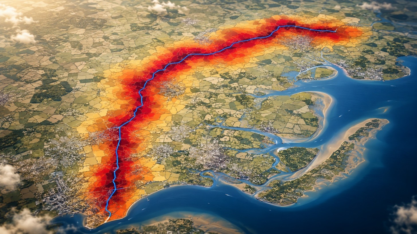
The Norwich to Tilbury reinforcement is a useful example because it sits directly inside the UK’s grid-delivery challenge. The wider project is designed to strengthen the transmission network across East Anglia and into the South East, where new low-carbon generation and demand are putting pressure on the existing system.
The section between Tilbury and Colchester is especially revealing. It contains many of the constraints that make transmission routeing difficult: dense settlements, transport corridors, designated landscapes, floodplains, water bodies and competing land uses. All candidate routes in the analysis were treated as 400 kV AC overhead lines, so the comparison is not really about technology choice. It is about route choice.
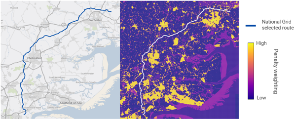
At first glance, the routeing problem looks like a familiar optimisation exercise. Avoid high-penalty areas. Keep the line reasonably direct. Minimise length where possible. Reduce obvious environmental and planning conflicts.
But when likely public opposition is mapped onto the same geography, a more interesting picture emerges. The route is not just passing through physical constraints. It is passing through social ones too.
The cheapest route is not necessarily the most buildable route
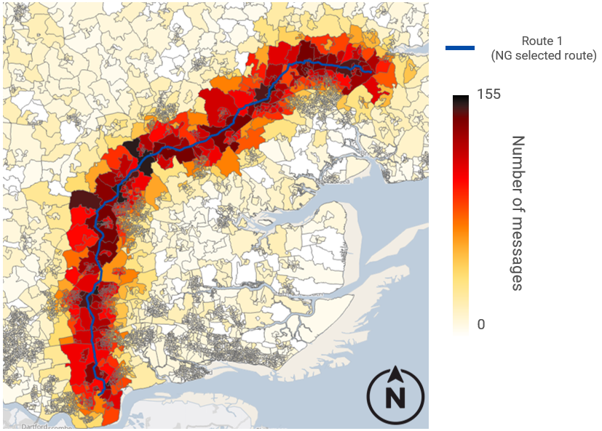
One of the most important findings is that the cheapest route was not the socially strongest route.
Across twelve feasible alternatives, the lowest-cost route was 71.4 km, with an estimated route-dependent capital cost of £286 million. The National Grid selected alignment in this segment was longer at 86.6 km and costed at £346 million. That is a £60.64 million premium, or 21.2% above the cheapest route.
On a narrow capital-cost view, that looks like a disadvantage.
But once social exposure is considered, the picture changes. National Grid’s route produced the lowest modelled opposition activity. Moving from the cheapest route to this route reduced the social activity score by 502message-equivalents. Expressed as a marginal trade-off, that means the additional £60.64 million buys down modelled opposition at roughly £121,000 per message-equivalent.
That number should not be read as a universal price. It isspecific to this corridor, this calibration and this set of assumptions. Butthe concept matters.
It makes visible something that is usually left implicit: thereis a price of acceptability.
Sometimes a longer route is not wasteful. It is a deliberate investment in reducing delivery risk. If a more expensive alignment avoids the communities most likely to organise, reduces the need for mitigation, and improves the probability of getting through consent without major delay, then the capital premium may be a buildability premium.
That is the shift in thinking the sector needs. Consent riskshould not sit outside the buildability case. It is part of it.
Consent risk has geography
Public opposition is often discussed as if it were a general atmosphere around a project: more or less support, more or less opposition, better or worse engagement.
But route-level consent risk is not evenly distributed. It has geography.
The heat map for the National Grid selected alignment shows activity intensifying close to the corridor, as expected. But the most important feature is not simple distance decay. It is the emergence of hotspots where proximity overlaps with local organising capacity and community continuity. In other words, objection risk concentrates where the route is close enough to affect people and where those people have enough shared identity, resources or proximity to organise.
This is a crucial insight for route planning.
A route may perform reasonably well overall but still contain specific locations where consent risk is disproportionately high. Those locations are the real project vulnerabilities. They are where planners should focus design iteration, mitigation and engagement effort.
The practical question is not simply:
How many people are near the line?
It is:
Which communities are near the line, how are they connected, and where might opposition become organised?
That is a much richer question. It turns consentability froma vague concern into a spatial design problem.
Small route changes can have large consent effects
The comparison between two alternative routes makes thepoint especially clearly.
The two routes are geometrically similar, but they diverge in a few key places. Those local deviations materially change the pattern of simulated opposition.
In one location, near Abberton Reservoir and the neighbouring communities of Great Wigborough and Peldon, Route 2 threads a narrow corridor between the reservoir and nearby settlements. That move looks like a routeing choice, but socially it creates a concentrated exposure band. In the analysis, local activity in this area rose from around 43 message-equivalents under Route 3 to around 156 under Route 2 — roughly 3.6times higher. Route 3 avoids that pinch point by taking a wider sweep away from those communities.
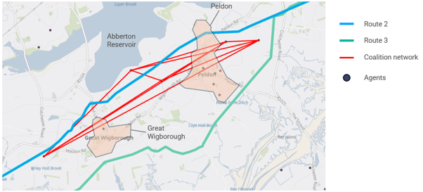
But the same comparison also shows why this is not a simple “detour equals better” story.
Elsewhere, Route 3 swings east to avoid woodland and improve clearances. On a physical constraints map, that looks like a cleaner move. But socially it brings the line closer to a town edge for longer. The result is more sustained local opposition activity in that area, and Route 3 ends up with a higher overall social score than Route 2.
That is the core lesson.
A route change can improve buildability in one layer while damaging it in another. Avoiding woodland may increase settlement exposure. Shortening the route may intensify opposition. Creating a wider environmental buffer may produce a tighter social corridor.
This is why buildability and consentability cannot be optimised separately. The route has to be tested as a whole.
The value of making acceptability explicit
The most powerful idea here is not the exact number attachedto the Norwich–Tilbury segment. It is the decision logic.
If one route costs £60 million more but materially reduces consent risk, that premium should not be hidden inside a general “balanced judgement”. It should be discussed openly.
What is the project buying with that extra length?
Which communities are avoided?
Which hotspots are reduced?
Which planning risks are lowered?
How much delay would need to be avoided for the premium to pay for itself?
What would late mitigation or redesign cost if the cheaper route proved harderto consent?
These are not soft questions. They are delivery questions.
The analysis also found that Route 1 performed strongly whenassessed across broader planning priorities, not only social activity. Underequal, environment-led, visual-led and planning-led weighting schemes, Route 1remained the composite-best option.
That reinforces the wider point: the selected route can beunderstood not merely as a line that avoids obvious constraints, but as a linethat trades capital cost for a more robust overall delivery case.
This is the sort of judgement infrastructure planning already makes, but often without making the marginal trade-off visible. The opportunity is to bring that trade-off into the open.
What this means for grid delivery
The UK does not have the luxury of slow grid expansion. The energy transition requires new transmission infrastructure at pace. But speed will not come from treating consent as an obstacle to be managed after route selection.
It will come from choosing routes that are more deliverable in the first place.
That means changing the role of early-stage routeing.
A conventional approach asks whether a route can be engineered. A better approach asks whether it can be engineered, consented and defended as one integrated proposition.
That has several practical implications.
First, consentability should be part of route generation, not just route review. If likely opposition is only assessed after a preferred alignment has been chosen, the project is already biased toward defending that choice.
Second, route appraisal should focus on pinch points. Consent risk is often local and non-smooth. A few communities or settlement edges can dominate the risk profile. Targeted micro-siting may be more valuable than wholesale rerouting.
Third, promoters should distinguish between capital cost and delivery cost. The cheapest route to build is not necessarily the cheapest route to deliver. Delay, redesign, mitigation and legal challenge can all erode the apparent advantage of a shorter line.
Fourth, acceptability should be treated as a budgeted trade-off. If a route premium buys down risk, that should be quantified and tested against the value of earlier, smoother delivery.
Finally, consultation should be informed by spatial intelligence. Communities can tell when alternatives have been dismissed too quickly. A routeing process that can show why specific choices were made, which hotspots were avoided, and what trade-offs were accepted is more defensible than one that simply announces a preferred line.
The broader lesson
Norwich–Tilbury is only one corridor, but the insight generalises.
New energy infrastructure will increasingly cross contested places. Transmission lines, substations, hydrogen networks, CO₂ pipelines, storage assets and renewable connections all face the same basic problem: the technically logical route is not automatically the deliverable route.
Infrastructure planners therefore need to stop treating buildability and consentability as separate tests.
A route that is physically possible but socially brittle isnot truly buildable.
A route that is cheap but likely to trigger delay may not be cheap.
A route that avoids one constraint while activating another may only look optimal because the model is incomplete.
The best route is not necessarily the shortest line. It is the line that survives contact with geography, communities, planning and time.
That requires a different mindset. Not “design first, persuade later”. Not “consult after the answer is chosen”. Not “social risk as a narrative appendix”.
Instead, routeing should be treated as the moment where engineering and consent meet.
Because for linear infrastructure, the route does not just determine where the asset goes.
It determines whether the asset gets built.

Start building today
